
From above, an ancient earthwork may look like little more than a change in the ground. Bring thousands of precise height measurements together, though, and roads, platforms and reservoirs can begin to emerge. That is what made a 2022 survey of Bolivia’s Amazonian lowlands so exciting.
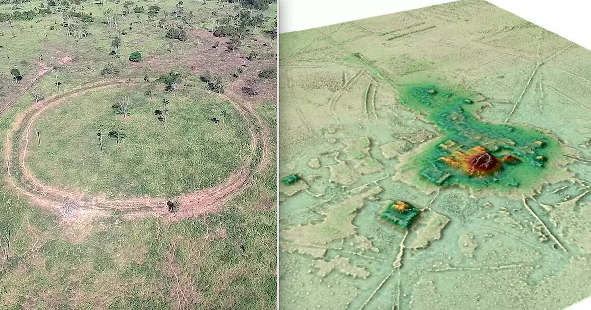
Researchers studying the Casarabe culture used airborne lidar to reveal the scale of an interconnected settlement landscape. Their Nature study described a sophisticated form of low-density urbanism in the Llanos de Mojos, a region of savannah and forest in southwestern Amazonia.
Why the settlement network changed the discussion
Canals, reservoirs, platforms and pyramidal structures made the settlement pattern much more substantial than a scatter of isolated huts. The 2022 report emphasized how water management and ceremonial architecture belonged to the same inhabited landscape. In the Nature paper, the researchers summarized the challenge to older interpretations this way:
“Our results put to rest arguments that western Amazonia was sparsely populated in pre-Hispanic times.”
Archaeologist Chris Fisher, writing about the research, placed it within a wider change in tropical archaeology:
“As with other tropical regions, the application of archaeological Lidar to the Amazon has launched a transformative process of discovery, documentation and reworking of assumptions held for decades regarding the nature of ancient societies. [This] work is the opening salvo of an Amazonian new orthodoxy that challenges the current understanding of Amazonian prehistory and fundamentally enriches our knowledge of tropical civilizations.”
These comments concern the evidence from the studied region. They should not be read as saying that earlier researchers knew nothing about Amazonian peoples, or that the whole rainforest had one uniform settlement pattern.
The size of the investigation also matters. The 2022 study placed the Casarabe culture within a region of about 4,500 square kilometers. Its airborne laser mapping sampled six areas, each approximately 10–85 square kilometers, totaling 204 square kilometers. The larger regional figure is therefore not a claim that the team flew a lidar survey over every part of that territory.
More than eleven isolated discoveries
The survey covered 26 sites, including 11 that had not previously been identified. Two already known settlements, Cotoca and Landívar, proved especially substantial: approximately 147 and 315 hectares respectively. The fresh discovery was therefore both new places and a better understanding of familiar ones.
Raised causeways linked settlements across the landscape. At the larger centres, the team documented platforms, U-shaped structures and conical pyramids reaching about 22 metres high. Canals and reservoirs were part of the same built environment.
These communities flourished roughly between 500 and 1400 CE. Describing their settlements simply as “lost cities beneath untouched jungle” misses the most interesting point: people had already been shaping this landscape for centuries.
How lidar makes the ground easier to read
Lidar measures distance with pulses of laser light. Some returns come from vegetation; others reach the ground through gaps. Processing those measurements helps researchers construct a terrain model with much of the vegetation removed from the view.
It is a model of measured surfaces, not an X-ray of buried rooms. Excavation, field survey and dating still matter. A beautifully clear outline cannot, by itself, reveal who lived inside it or what happened there.
The next question: how were these communities fed?
A 2025 study of Casarabe farming added an important piece. Researchers combined remote sensing and fieldwork with analysis of microscopic plant remains. They found evidence for drainage canals and farm ponds that helped manage opposite seasonal problems: too much water during the rains and too little during the dry season.
Maize remains in the sampled agricultural settings pointed to an intensive farming system in the savannah. The findings help connect monumental architecture with everyday necessities. Buildings need builders, and builders need reliable food and water.
Try reading the landscape as a connected system
When looking at a lidar image, follow the lines between the prominent structures. Where could people move? Where might water collect? Which features repeat? Those questions make the image far richer than a search for the tallest pyramid.
Different materials can preserve similar clues. At Zeugma, mosaic floors reveal how Roman households arranged and decorated their rooms. In Bolivia, earthworks reveal connections at the scale of whole settlements. Both invite us to imagine inhabited places, with work, movement and ordinary routines around the monuments.
Credits and references: nature.com (source) · IFL science.


COMMENTS