

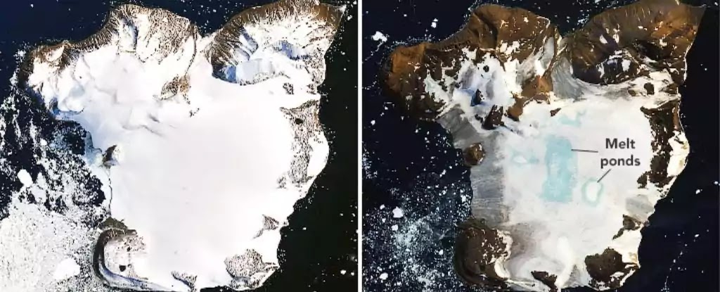
Eagle Island on February 4 (left) vs February 13 (right) (Joshua Stevens/Landsat/USGS/)
Eagle Island on February 4 and February 13, 2020. NASA Earth Observatory images using Landsat data from the U.S. Geological Survey. Source.
NASA pictures show pronounced local surface melting on Eagle Island near the Antarctic Peninsula. [source] The photos show an amazing view, but just a few days back we wrote about it being warmer in Antarctica than Louisiana, with record highs at Argentina's Esperanza research station (65 degrees Fahrenheit). The pictures below tell the story.
Antarctica is supposed to be an incredibly cold place. The annual mean temperature of the continent's central area is -57°C (−70.6°F); even the coast averages approximately -10°C (14°F).
In just one week in the beginning of February 2020, modeled melt was equivalent to roughly one-fifth of the island’s seasonal snow accumulation.
On February 6th 2020, the weather station at Esperanza Base on the Antarctic Peninsula - the northernmost tip of the continent - logged the hottest temperature ever recorded on Antarctica' mainland at 18.3°C (64.9°F).
This recent heatwave lasted for about a week, and photos of Eagle Island, taken by the Operational Land Imager on Landsat 8, have recently taken a picture that clearly reflects the destruction taking place.
Eagle island is near Graham Land in the Antarctic Peninsula. The record-high temperatures have resulted in substantial surface melting and the formation of meltwater ponds on Eagle Island. At the same time, areas towards the middle of the island saw melt ponds form astonishingly quickly.
By February 13th, you can see much of the snow gone and the small blue spots are ponds created by the melted snow.
This isn't even the first heatwave this season, but represents the third major melt event of the 2019-2020 Southern Hemisphere summer, with both November and January also suffering from exceptionally warm weather.

Air temperatures on February 9. (GEOS-5/NASA)

What happened during the warm spell?
NASA Earth Observatory’s account links the changes with unusually warm conditions around the northern Antarctic Peninsula. Nearby Esperanza Base recorded 18.3°C on February 6, 2020. Landsat 8 captured the before-and-after views.
The report cited modeled snowmelt estimates for Eagle Island, including a loss equivalent to roughly one-fifth of its seasonal snow accumulation during the episode. That is a local, time-specific estimate. It does not mean that one-fifth of Antarctica’s ice disappeared.
What blue ponds show—and what they do not
Meltwater collecting at the surface is evidence of thawing, but a photograph alone does not provide the full water balance. Scientists combine imagery with measurements and models to investigate how much melted, where the water went and what persisted afterward.
Cloud cover, shadows and different image dates can also complicate comparisons. A useful caption should identify the instrument, location and acquisition date rather than offering a dramatic percentage without its denominator.
A closer look at a changing region
Start by locating the island on a map, then compare the same features in both images. This gives the change a scale that a cropped social-media picture can hide.
Sea ice plays a different ecological role nearby: the Halley Bay emperor penguin breeding failures show why the timing of ice breakup matters to wildlife. Our article on a rectangular Antarctic iceberg explains another striking image from the region.
Use the dates as part of the picture
Before comparing the blue and white areas, note the interval between the two observations and whether the view covers the same ground. A striking short-term change is meaningful without standing in for the entire history of Antarctic ice. The images let readers examine a particular episode. Longer-term conclusions need observations extending beyond this single pair.
Explore the related article: Tonga's 2022 Eruption in Satellite Images.
Additional source and image references: Before-and-after satellite views of snow and melt ponds on Eagle Island


COMMENTS